I'm from the Missouri Ozarks. That means I grew up south of I-70 and North of Little Rock Arkansas. It's a big chunk of land that most people never see. It's hilly, slightly mountainous terrain. Typically described as "rugged". I started mountain biking in those steep, rock strewn hills, and I probably know every spot in which to ride a bike off-road in all of the southern half of the state. I have maps of places that no one knows about. I made most of my own maps long before Google Earth or anyone had access to such amazing tools such as GPS. I've long been dreaming about linking all the major riding areas together in one long ride. And thinking into the future, even marking it as a long bike specific route. Over Thanksgiving last week I finally linked a large chunk of this ride together.
I would be starting from my parents farm, which is nicely located in the middle of a huge chunk of the Mark Twain National Forest.
Despite the maps, most of this ride was simply in my head. It had been at least 8 years since I had ridden many of the trails. However, not much in the Ozarks changes, so I was hopeful my memory would serve me well.
I was heading north, from our farm near Beaver Creek, Kissee Mills Mo. The plan was to cross two chunks of Mark Twain National Forest land, one near Taneyville MO, the other near Bradleyville Mo. Then some pavement to the Swan Creek Trail system near Garrison MO. From there crossing over hwy 125 to the old Deveraux Ridge Trails. My parents used to ride there before I was born. I would then finish by crossing the center of the massive Chadwick Motorcycle Use Area trail system. Future plans call for including the Glade Top Trail system near Rueter MO and furthest south, and also the Busiek State Forest making it the furthest west, near Ozark MO. Simply including these two systems will ad at least a days ride, possibly two. I would expect mileage for the whole route to come to near 75, and much of that on achingly slow rugged trail.
The morning dawned crisp, but with a good chance of reaching the 60's for the day. Fog lined the creek below the house.
Mom and Dad took me to breakfast in Taneyville and then dropped me at the first of many forest service roads.
The route quickly got down to business, turning from gravel to dirt and then to loose baby head rocks, which are so much a part of riding in this landscape.
I find air time where I can, and it's no different in the Ozarks, the "air" just isn't as big as it is in other places, but ya know I try...
With the first chunk of forest finished I would connect to the next by riding hwy 76 toward Bradleyville and the top of Cedar "Holler" Hill.
This road was tempting, as I do like a good rough road, but if I remember the story correctly, it was named after a farmer's daughter who was killed in a car/pedestrian accident here on this corner and then their house burnt down later that year. Kind of a "bad" road indeed.
Road 612 probably has an excellent Ozark name if I could find the right old timer to tell me its history. But since I don't know its colloquial name I will call it "Animal Encounter Road." As I was cresting a hill I watched a bird ascending quickly upward and then BANG!!! it fell to the earth dead. I hurried onward not wanting to get shot my-self. As I sped up, heading steeply downhill I spooked a deer. It ran along beside me at 25 miles an hour, deftly maneuvering through the trees. It seemed shocked that it could not out run me. It must have tried for over a quarter mile before veering off in another direction.
The longest stretch of pavement was on UU hwy and also had some steep climbing. As I reached a high point the trees opened up and I saw before me a vast swath of forest. I would need to cross the entire Swan Creek Trail System which was the least known and explored by me. Even when I rode there 8 years ago, I was lost most of the time. Today would be no different. The far horizon line of the picture below would be my goal for most of the afternoon.
Turn left at the sign above...uhhhh, I think this used to be the sign for Tin Top Ridge, but who knows? I dove into the forest happy to be leaving pavement.
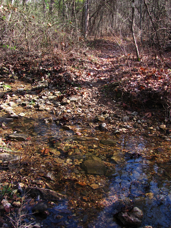
I crossed numerous creeks and climbed and descended numerous valleys and hills. At every trail intersection I would take the trail that most seemed to head west. Eventually I came to Swan Creek, too deep to get across without getting totally wet. I removed my shoes and waded across, reaching the other side feeling completely spent. It had taken hours to cross this trail system and I had two systems yet to go to complete my goal for the day.
Near the old Union Church in Garrison MO, is the house of an old friend. As tired as I was I really hoped they would be home. I wanted a glass of milk! But, being the day after Thanksgiving nobody was around, so I resolved to pedal onward up the steep grade to Deveraux Ridge.
The above picture makes this road look easy, but I disagree. Right about here is where I also ran out of water!
With trail like this facing me for the next many miles I was really glad I had just scored a bottle of water from some hunters. They thought my orange rocker link on my bike made good sense considering where I was. I'm not sure they believed me about how far I had come on this day. I thanked them and climbed into loose boulders that my Mom and Dad had once ridden on their motorcycle's, before I had been born.
Hard to tell what trail I was on, but again I kept heading west and finally popped out on H hwy and crossed over into the Chadwick Motorcycle Area. I scored another bottle of water from a moto "camp." (big RV, Satalite TV, good smelling food cooking) The lady here asked how far I had ridden and when I told her she exclaimed.... WHY???? I didn't really know what to say, as I was wondering WHY?? at that point too.
The steep, rocky, technical, muddy, trails of Chadwick crushed what was left of me. I struggled into Cobb Ridge Moto Camp with the sun near the horizon. I called Mary and my Dad to come get me and sat down to eat what was left of the food in my pack.
This trip was a success. I crossed a large portion of Missouri in one day, never touching private land and spending most of it off-road. The potential for an even bigger ride, with a mandatory over night is possible by including Busiek State Forest, and Glade Top Trail National Scenic By-Way. I'm dubbing this route the Mark Twain Trail, since most of it is in the National Forest. Another option, only open to hikers, is to cross the Hercules Glades Wilderness, making for a really BIG hike. Bikers, sadly, will have to ride around the wilderness on county roads.
The above map shows what I rode in black, and then red dots depict what I propose is possible. Years of exploring went into this, and it will take someone local who can spend time figuring out the best options through the many trail systems, and GPSing a route, to make this something others could re-create. I don't live here anymore so I'm challenging someone else to work on this. Missouri needs a long distance off-road bike route. This one is as good as any. If anyone wants to take this on, I'll help all I can. Now, GO RIDE YOUR BIKES OZARKERS!!!!


Dude, this is really something. I too grew up playing in the Ozark "mountains" and have dreamed of this ride. I hope to someday put it together. I find myself too ocupied with the Rockies these days... Good work on getting it done. I will favorite this page for the future.
ReplyDeleteThe only problem I see with it right now is through the hercules wilderness area. The trails are great but "technically" bikes are frowned upon. I think it could be bypassed to the north. I'll check it out. I would like to investigate the old Cane Creek Ext. as a possible spur. Nice work Baldknobber.
ReplyDeleteI didn't mean bikes should ride through the official wilderness, just that if a person wanted to hike through it, you could extend this ride by a lot. Mike Curiak and Scott Morris once took their wheels off, strapped their frames to their packs, and used their wheels as walking sticks while crossing a section of wilderness on the Continental Divide Route. There are some off-road options from Kane Creek to Blair Ridge, but Blair Ridge was recently paved. Kopek, I think you are the Baldknobber I'm looking for to put this route together! Get R Dun Brother Baldknobber!
ReplyDeleteI might be the saddest person in the world that I wasn't around to provide my friend with a big glass of milk! Love the pics - miss you Landon! -Melany
ReplyDeleteLandon you are a hard-core biker nut and the pictures on the creek down tintop, well, you were infringing on my deer hunting territory. I couldn't believe what I saw. Just up the hill from that branch on the right was where I like to walk in to hunt. Bet you got there faster! I looked for a monster buck at the end of your trail photos and didn't see one so I'm like the lady that asked WHY????? Sorry we weren't home. We did have 2 full gallons in the fridge. Ha! Come back. We're here now. -Brett
ReplyDelete