You don't see a lot of purple dirt. Even out West where colored rock comes in many hues, purple is not normally one of them. But then there is only one Capitol Reef, known as "The Sleeping Rainbow."
We were heading for the Burr Trail, which is an old cattle trail through the Reef to Escalante National Monument.
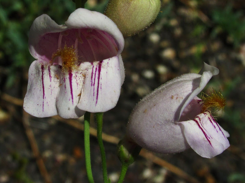
Even the flowers seem emulate the soil from which they came. (flower pic below by Mary)
Escalante is a land of color, from purple to dark reds, mixed with stark white. The landscape is a freak show of Crayola color painted on rock.
Gasoline? .42 cents a gallon? This old relic still stands in front of an old store in Boulder UT.
As we neared Escalante town, we noticed the turn off for "Hole in the Rock." We are notorious for taking side roads on a whim, and this one was no different.
First, a history lesson. In 1879 Mormon pioneers set out to establish a colony on the San Juan River near Bluff Utah. Indian troubles had made the easier route via "Moap" (meaning mosquito water, which morphed into Moab) problematic. From Escalante these pioneers set out in covered wagons across the most inhospitable chunk of land in the lower 48. There chosen route would guarantee one of the most amazing adventures of all time. The going was fairly easy at first. The rock pictured below was known as "Dance Hall Rock" where they held square dances and "wild party's."
We too found the going pretty easy up to Dance Hall Rock. The road was wide, sandy and full of washboards. I was able to cruise at about 60mph hovering above the bumps in a floating, mostly in control manner. The sign at the start mentioned 53 miles, which would mean we would need enough fuel for over 100 miles of Utah road. A half a tank should be enough right???
As the road turned into a more normal Utah affair, meaning speeds below 10mph and skid plate breaking rocks and deep pillowy sand wallows, we decided to hide our bikes in the sage brush so we could drive more aggressively and not break our bike rack. As the picture below demonstrates, the bikes would have been nice when we had to ditch the truck and start walking. As the fuel gauge hit 1/4 tank, I new we might have already went too far to make a return trip.
As we shut off the truck, we debated how far yet we had to go. We figured we were within 3-5 miles of "Hole in the Rock." This was painfully close, and yet sooo far away. I don't really like to walk. It was also easily over 100 degrees. But we wanted to see this famous crack in the wall where covered wagons were lowered on ropes nearly 1000 ft to the Colorado River.
I'm glad we walked. The two pictures above show just how amazing it must have been to lower wagons, livestock, horses and people down to a roaring river. (now a stupid sess pool of a lake, IMO)
Once seen we headed back to the truck with the real possibility of running out of gas and hoofing it or biking it back to Escalante. We decided to camp, and get an early start in the morning. The below pics were taken by Mary a we hiked back to the truck.
Navajo Mountain--I had read a lot about this chunk of rock and seen it distantly from Arizona many times, but we had never been this close. In the left side of the photo you can see what looks like rain starting to fall on the flanks of the mountain.
It soon became clear that this "rain" was actually a scary brown cloud moving toward us rapidly. It was eerie, there was no wind, it was completely calm, yet it quickly moved toward us.
I asked Mary if possibly a nuclear bomb had went off, and we were about to be the last two people to hear about it?
Suddenly the wind roared as the dust cloud hit. We had sand in our hair, our faces and we could taste it. The sun was soon blotted out as we trudged back to our truck and a miserable dusty hot night in camp.
When we awoke the next morning, the storm was gone, but its dusty remnants made for one of the most colorful sun rises I have ever seen.
It is possible to affect the color of rocks in photo's via my editing software, but I can promise you that these two pictures were not touched. The rocks were really that red, the sky really that blue and the moon still shown brightly. As we pampered the truck over the gnarly jeep road back to civilization, we marveled at what an amazing world we have the pleasure to inhabit.
We rolled into Escalante town, with oil leaking from both of the trucks front shocks, and managed to put 16.98 gallons into a 17 gallon tank. I'm no stranger to cutting it close, but this was one of the closest! Stay tuned for day two!


living the dream you two. thanks for the gorgeous photos. amazing. -j.t.
ReplyDelete